
Geoscientists Create Deeper Look at Processes Below Earth’s Surface with 3D Images
Geoscientists at UT Dallas recently used supercomputers to analyze massive amounts of earthquake data to generate high-resolution, 3D images of the dynamic geological processes taking place below the Earth’s surface.
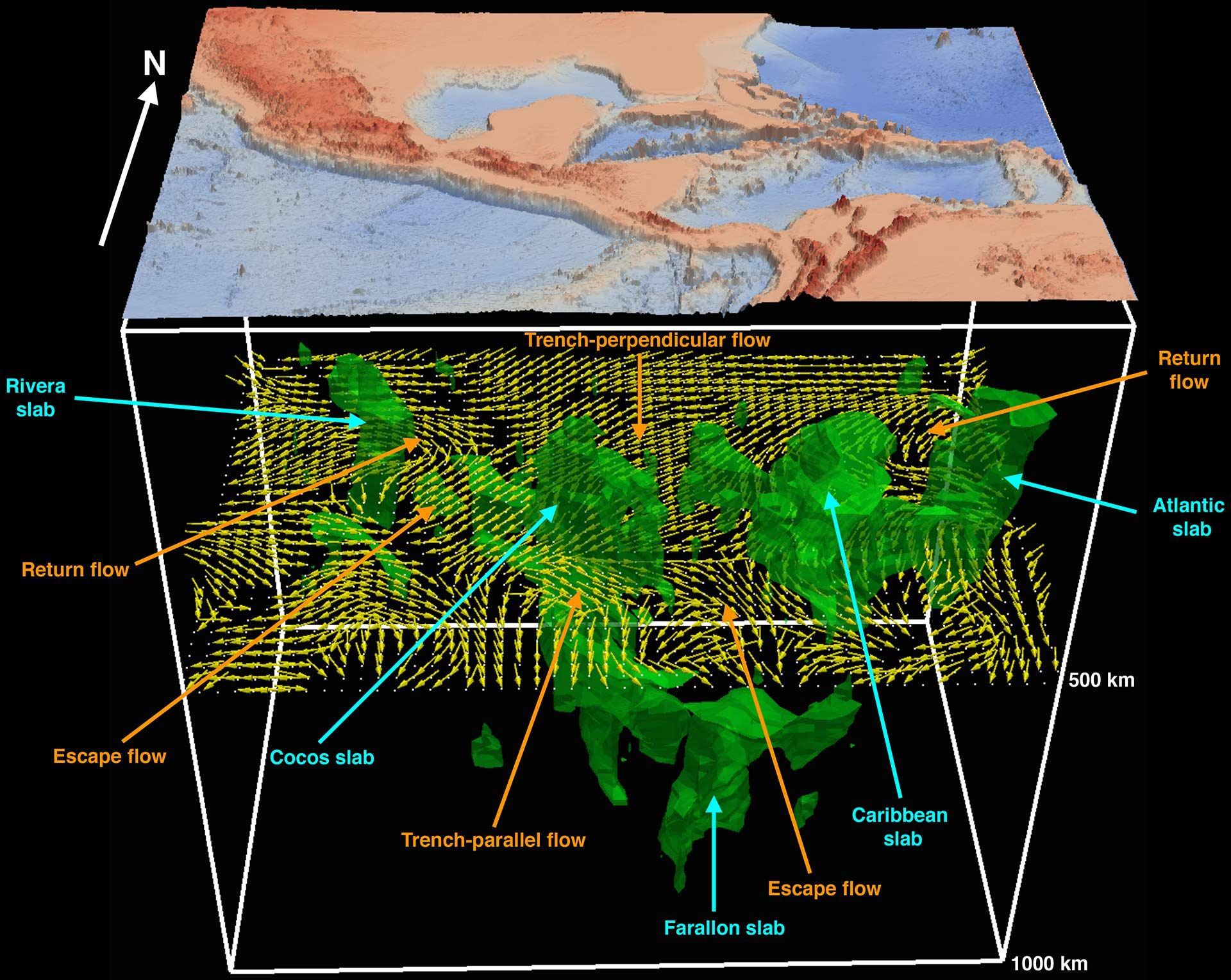
In a study published April 29, 2020, in Nature Communications, the research team described how it created images of mantle flows in a subduction region under Central America and the Caribbean Sea using a computationally intensive technique called a full waveform inversion (FWI).
“This is the first comprehensive seismic study to directly image 3D mantle flow fields in actual subduction environments using advanced FWI technology,” said Dr. Hejun Zhu, corresponding author of the study and assistant professor of geosciences in the School of Natural Sciences and Mathematics. Jidong Yang PhD’20 and Dr. Robert Stern, professor of geosciences, are the study’s co-authors.
Between the thin layer of the Earth’s crust and its inner core lies the mantle. Earth’s crust is broken into pieces called tectonic plates. These plates move across and into the mantle very slowly. At regions called subduction zones, one plate descends under another into the mantle.
“The sinking of oceanic plates into the Earth’s mantle at subduction zones is what causes the Earth’s tectonic plates to move and is one of the most important processes taking place in our planet,” Zhu said. “Subduction zones are also the source of many natural hazards, such as earthquakes, volcanoes and tsunamis. But the pattern of mantle flow and deformation around descending plates is still poorly understood.”
Zhu and his colleagues tackled the problem using a geophysical measurement called seismic anisotropy, which measures the difference in how fast mechanical waves generated by earthquakes travel in different directions inside the Earth.
“When a diver dives into water, the water separates, and that separation in turn affects the way the water moves around the swimmer,” Zhu said. “It’s similar with oceanic plates: When they dive into hot mantle, that action induces mantle separation and flow around the plates.”
The research team created the images using high-fidelity data recorded over a 10-year period from 180 earthquakes by some 4,500 seismic stations located in a grid across the U.S.
“Previously we couldn’t ‘see’ under the Earth’s surface, but by using this technology and this very wonderful data set, we are able to delineate the 3D distribution of various seismic phenomena and tell at what depths they are occurring,” Zhu said.
The images confirmed that the plates in the study region are not large, solid pieces but rather are fragmented into smaller slabs.
“This looks different from the textbook depictions of tectonic plates coming together, with one solid piece of oceanic plate descending under another solid piece,” Zhu said. “Some researchers have hypothesized that this fragmentation occurs, and our imaging and modeling provide evidence that supports that view.”
The research was funded by a grant to Zhu from the National Science Foundation’s Division of Earth Sciences.
– Amanda Siegfried
 Dr. Hejun Zhu

